
IIn 1960, a Utah journalist first called Utah’s powder “The Greatest Snow on Earth.” The phrase took off, bedecking Utah license plates now since 1985. The lore went that the winter storms dumped most of their moisture on the Sierra Nevada mountain range on their way east, leaving the driest, fluffiest snow for Utah.
Few people know the ins and outs of Wasatch Mountain snow better than Jim Steenburgh, professor of atmospheric sciences at the University of Utah, whose twitter handle is @ProfessorPowder. In 2008, he started examining the “greatest” claim with meteorological science, an effort that culminated in a 2014 book, Secrets of the Greatest Snow on Earth. Since 2010, he’s blogged regularly about Utah’s weather at wasatchweatherweenies.blogspot.com. The blog often documents the so-called Steenburgh Effect. “Whenever [Steenburgh] leaves Utah in the winter, it tends to snow,” a colleague wrote in 2017, “and often it snows a lot.”
Steenburgh’s research has taken him to the Tug Hill Plateau in New York and to the mountains of Japan. He served on the weather support team for the 2002 Winter Olympic Games and has consulted with teams for most of the winter games since then. I talked with Steenburgh about some of his most-frequently asked questions, and about both the past and the future of Utah’s superlative snow.
Gabrielsen: With all of that snow comes the risk of avalanche. What makes snowpacks unstable, and what avalanche warning signs should skiers look for?
Steenburgh: Four major risk factors produce injuries or fatalities in avalanches: terrain, snowpack, weather, and humans. The human factor is probably most critical. On low-hazard days, most terrain can be skied safely. On high-hazard days, most skiers avoid avalanche terrain—typically, slopes that are 30 degrees or steeper, although there are exceptions.
Most accidents happen, however, on days when the information available is less complete and humans elect to ski a slope that ends up avalanching. While there are important warning signs, such as recent avalanche activity, collapsing or “whumpfing” snow, or weak layers in the snowpack, perhaps the hardest ones to see are the shortcuts that we make as humans when evaluating risk and making decisions.
Gabrielsen: You’ve skied all over the country, and internationally, as well. Where else could lay claim to the greatest snow?
Steenburgh: Four mountainous regions have outstanding powder skiing climate. Three are in North America: The Wasatch Range, the Teton Range, and the mountains of interior British Columbia. These receive abundant, high-quality snowfall and also have great terrain.
The fourth is the mountains of northwest Honshu and western Hokkaido, Japan. This is my favorite snow climate. Those regions are inundated by “sea-effect” snowfall from about mid-December through February during what they call the winter monsoon. The Sukayu Onsen observing site in the Hakkoda area of northern Honshu is probably the snowiest regular observing site in the world, with an average annual snowfall of 694 inches. In January, the average snowfall is 181 inches. There is no surer climatological bet for deep powder skiing than northwest Honshu and western Hokkaido in late January.
Gabrielsen: People also frequently ask if recent poor skiing seasons are due to climate change. Are they?
Steenburgh: This is a complex question. Yes and no. Our warming climate is decreasing the amount of wintertime precipitation that falls as snow and increasing snowmelt events. There is a lot of variability from winter to winter, but the dice are becoming loaded for warmer winters. The lack of wintertime precipitation in recent years appears to be due to the whims of the jet stream. We’ve simply gotten into a period where precipitation has been subpar.
Gabrielsen: Was there a “golden era” of skiing weather in Utah sometime in the last 50 years?
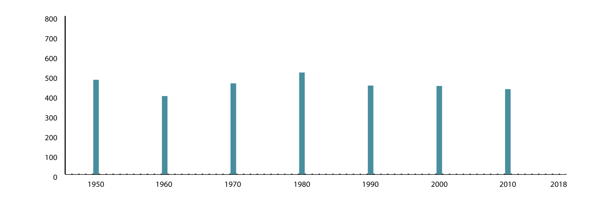
Steenburgh: Meticulous snowfall records show that the 1980s and 1990s were the two biggest decades at Alta based on mean annual snowfall. Sorry, kiddos, but your parents had it better than you.
Gabrielsen: What are some things meteorologists can do now with snow forecasting that they couldn’t in past years?
Steenburgh: Forecasts are demonstrably better today than they used to be, although we struggle more here than just about anywhere else. But we can access real-time weather observations and radar imagery easily, so I can make my ski plans when I wake up in the morning. I think we will see dramatic improvements in forecasts as our computer models become detailed enough to properly account for the effects of the Wasatch Mountains and Great Salt Lake. My group developed computer models that were used for weather forecasting during the 2002 Winter Olympics, and I’m chomping at the bit to do it again if we get the 2030 games.
Gabrielsen: How might the winter climate in Utah change over the next 50 years?
Steenburgh: There will still be year-to-year and decade-to-decade variations in snowfall and skiing quality, but global warming is going to have an increasingly caustic effect on Utah snow. This means warmer winters, a greater fraction of wintertime precipitation falling as rain instead of snow, more midwinter snow loss events, and heavier snow. These changes will be most obvious and emerge most rapidly in the lower elevations, but the upper elevations will eventually suffer, too. I suspect that upper-elevation ski terrain in the Cottonwood canyons will become an increasingly precious and valued commodity as we move through the 21st century.
Gabrielsen: What might the rest of this ski season hold in store? Will it end up as a good year or a bad year?
Steenburgh: I have absolutely no idea. If anyone tells you anything different, don’t buy what they are selling. There’s never been much skill in seasonal forecasts for northern Utah, and I’m not going to pretend that there is.
LITTLE COTTONWOOD’S ANNUAL SNOWFALL
This chart contains the historical snowfall data as recorded in Little Cottonwood Canyon at the Alta Guard Station, which is now part of the Utah Department of Transportation’s avalanche snow safety operation.
—Paul Gabrielsen is a science writer for University Marketing & Communications.