Vol. 9 No. 1 THE MAGAZINE OF THE UNIVERSITY OF UTAH Summer 1999
Continuum Home Page
- University of Utah Home Page - Alumni
Association Home Page
Questions, Comments - Table of Contents
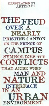
LIFE ON THE EDGE
The feud over a nearly pristine canyon on the fringe of campus symbolizes the conflicts that arise when man and nature interface in an urban environment.
by Anne Palmer Peterson
 A
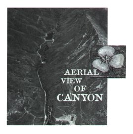
barometer of what the region would look like without us, Red Butte Canyon
is not only the University's neighbor but a stunning outdoor laboratory.
Under the Army's and now the U.S. Forest Service's watch, it has remained
one of the only undisturbed canyon watersheds in the Great Basin. One
would be hard-pressed to find any public-lands expert who doesn't cherish
the area as an environmental resource. The problem is finding a public
entity willing to claim responsibility for its overall management.
A
barometer of what the region would look like without us, Red Butte Canyon
is not only the University's neighbor but a stunning outdoor laboratory.
Under the Army's and now the U.S. Forest Service's watch, it has remained
one of the only undisturbed canyon watersheds in the Great Basin. One
would be hard-pressed to find any public-lands expert who doesn't cherish
the area as an environmental resource. The problem is finding a public
entity willing to claim responsibility for its overall management.
Today there is more passion than planning for the protection of Red Butte Canyon. The Army gave it away when Fort Douglas was downsized as a military post in 1948. It no longer needed the fenced watershed for culinary water, so Red Butte Canyon was transferred to the Bureau of Land Management and then to the Forest Service. The Forest Service continued to keep out people while the Army pledged to store water. A dam on Red Butte Creek built in 1930 created a reservoir which now sustains waterfowl and wildlife rather than enlisted men and women.
A year ago, the Army suddenly abandoned the 128-foot-high earthen dam. Now the Forest Service says it cannot afford the $30,000 a year it costs to operate the orphaned structure. Blaine Rushton, the dam tender who monitors the reservoir's water level, doesn't know from one month to the next whether his contract will be renewed. Rushton used to work for the Army Corps of Engineers and, in the course of his employment, did more than check gauges. His responsibilities included cleaning spillways of blockages, adjusting gatehouse valves, and removing roots infiltrating the dam. No one does that now.
Salt Lake County has considered taking over the dam as part of its flood control responsibilities, but only if the federal government makes an estimated $3 to $5 million in repairs to reinforce the dam. Senator Bob Bennett is leading the effort to secure federal funding, as well as trying to resolve the management feud that has pitted the Department of Agriculture against the Department of Defense in the U's backyard.
Meanwhile the Fish and Wildlife Service is using the reservoir as a holding area for the endangered Bonneville cutthroat trout and June sucker, which has since spawned in the reservoir at Red Butte. Though Fish & Wildlife is paying Rushton to check the reservoir's water level several times a week, the fisheries experts aren't interested in taking over management of the dam.
In all, there are 6,700 acres of watershed land, crest to crest, in Red Butte Canyon. Protecting and accepting liability for that much land is an awesome responsibility.
Having received Congressional designation as a Research Natural Area, Red Butte Canyon is an intriguing subject for possible research. With the exception of sandstone quarrying that took place when pioneers first arrived in the Salt Lake Valley, the canyon has been remarkably well protected. It has been kept free from farming, grazing, and other human impacts. This is unusual for a canyon so close to a metropolitan area, observes biology professor Jim Ehleringer. "From a conservation/preservation standpoint, the canyon reflects what this region looked like when Brigham Young came down the other canyon 150 years ago. If you want to see what that looked like, you go to Red Butte. There's a world of difference in terms of vegetation and stream quality from anything anywhere else around," he explains. Ehleringer's 1992 article on the history, flora, geology, climate, and ecology of Red Butte Canyon, published in The Great Basin Naturalist, makes a strong case for the need to protect Red Butte as one of the few remaining undisturbed riparian ecosystems in the Intermountain West.
Ehleringer and other researchers are anxious to engage in such studies as how rainfall and unregulated natural streamflows sustain vegetation ranging from grasslands on the canyon's lower limits to Douglas fir and aspen stands above the reservoir and Red Butte Creek. "There are quite a few people who would like to see increased activity and management in the Canyon, but until the University either describes what its research mission is or the Forest Service clarifies its constraints, it actually forces most of us who want to do more research in the canyon to go elsewhere," he says. Challenges include road and automobile restrictions in the Research Natural Area that prevent installation of heavy scientific instruments. Coordinating research activities with the Forest Service has been so difficult that Ehleringer says the Biology Department has had to move three projects from Red Butte to either the Uintas or Washington State.
Scientific investigators aren't the only ones interested in the appearance of untrammeled fauna. Curious citizens want admittance, and mountain bikers want access, too. Encroachment and enforcement are growing problems. "We're trying to protect it, but this place is under siege because of all the growth in the Salt Lake Valley," declares the Forest Service's David Reem.
Recreational pressure, of course, isn't restricted to the protected area of Red Butte Canyon. Citizens and University representatives have begun discussing the preservation of access to the foothills east of campus at facilities planning meetings hosted the fourth Wednesday of every month. Schoolteachers Caryl Brown BFA'87 and Cheryl Manning organized Citizens for Open Spaces to voice concerns about development adjacent to the Bonneville Shoreline Trail. The group has focused on preserving 32 acres of land between the Visitor Center at Red Butte Garden and This Is The Place Heritage Park.
The U acquired the land from Fort Douglas in 1968 to establish Research Park. Economic development was the park's primary objective. In its application to the federal government, the U pledged to lease space on the 300 acres to occupants that would develop beneficial relationships with the University and its academic programs. Its success in fostering research spinoff companies has made it an international model for planned research parks. In 1995, it was the country's twelfth largest.
Research Park Director Charles Evans BS'64 MBA'65 emphasizes the role that the master plan adopted for the park in 1970 has played in guiding its mission. Lease revenue contributes $500,000 to $1 million a year to a University foundation that supports non-funded research grants. Were the University to forego building on the land Citizens for Open Spaces has proposed excluding from development, Evans says the loss to the University would be approximately $10 million for the value of the land. The University also would fail to profit from an additional $1 million annually in land lease income, he says. Buildings leased in Research Park revert to the University, which may use them for academic programs. Most leases are for 50 years.
The 32 acres along the foothills could be developed into three plots roughly equivalent in size to the lot leased by the Huntsman Corporation in 1995. The Bonneville Shoreline Trail would be slightly re-aligned – an adjustment that Bonneville Shoreline Trail trustee Rob Macleod says would take better advantage of the terrain's curving topography. The trail section above Research Park is now situated atop a pipeline corridor. Public access to the popular trail system will remain, Evans and other U administrators pledge.
The Utah Museum of Natural History has designs on the 17-acre lot next to the Red Butte Garden Visitor Center. It has been set aside while volunteers and staff explore the feasibility of financing a museum on that site. Were the U to forego the lease income and use the land for a museum, surrounding Gambel oak would be incorporated into outdoor exhibits, according to museum director Sarah George.
An avid cyclist and hiker who brings her junior high art students to sketch in the foothills, Brown believes that the state should re-examine its priorities, weighing economic development against open space. "People need open spaces near the city, and once they're gone – they're gone forever," she laments.
Red Butte Garden Director Mary Pat Matheson BS'81 MPA'93 says that the University's involvement in long-range planning for the foothills stalled as tension mounted over the dam's management. "It has created major problems from the University's perspective, because if the dam gives, it floods Research Park," notes Barbara Bentley, an adjunct professor of biology, and environmental science director at Red Butte Garden. The Forest Service intends to continue managing the Research Natural Area, and would also like clarification from the University on the appropriate role for research within the canyon. Once that is resolved, there are the matters of managing security and recreational use to address.
As a protected natural resource, the Research Natural Area within Red Butte Canyon has helped increase understanding of dynamic biological processes and the human effect on the region's ecological health. Pressures on the surrounding environs provide a stark contrast, the severity of which is present in the minds of neighboring scholars, if not the public servants squabbling over which must step forward to ensure protection of the canyon, the dam, the trail, and the land.
– Anne Palmer Peterson is editor of Continuum magazine.
Continuum Home Page - University of Utah Home Page - Alumni Association Home Page
Questions, Comments - Table of Contents
Copyright 1999 by The University of Utah Alumni Association